
Confined Space Drone Culvert Survey with the Environment Agency

Overview
Concealed by years of urban development, culverts are often lost and their condition can deteriorate quickly. Finding records and interpreting them from old maps can often be challenging.
These types of structures also pose significant challenges for maintenance and safety assessments.
Traditional methods of inspection can be time-consuming, expensive, and sometimes hazardous, often requiring manual entry into confined and potentially unsafe spaces.
This case study explores the innovative approach adopted by Team UAV, demonstrating the capabilities of modern drone technology in overcoming these traditional inspection hurdles.
The use of drones enables rapid data collection and the ability to access hard-to-reach areas, providing unprecedented insights into the health and integrity of critical infrastructure.
The Challenge
The core challenge involved accurately determining the culverts' locations beneath built-up areas and conducting thorough inspections without compromising safety. This required a non-invasive yet highly detailed and precise surveying method, capable of navigating the challenging environments of confined space water culverts.
Given the critical role these culverts play in urban drainage systems and their impact on public safety and infrastructure integrity, the urgency for a non-disruptive, accurate, and safe inspection method cannot be overstated. The approach must not only safeguard the safety of the personnel involved but also ensure the continued functionality and reliability of these essential urban infrastructure components.
The Solution
To meet these challenges, Team UAV used a specialised confined space drone equipped with a LiDAR sensor, a 4K camera, and ultra-bright LED lighting surrounded by a collision-tolerant cage that allows the drone to get up close visual data and dense point clouds from a single flight. The solution involved a comprehensive survey process, integrating above and below-ground data to create a detailed assessment of the culverts.

Initial Planning & Stakeholder Liaison
In the preparatory stages of the project, Team UAV dedicated significant effort towards comprehensive initial planning and establishing effective communication channels with key stakeholders.
This foundational phase was characterised by a strategic approach that involved in-depth consultations, close liaison with the Environment Agency, and other pertinent stakeholders directly impacted by or involved in the project.
Our objective during this period was to foster a collaborative environment and secure a consensus on the project's scope, objectives, and anticipated challenges.
The initial planning stage commenced with a thorough analysis of the project requirements, facilitated by engaging discussions with the Environment Agency. These dialogues were crucial in gaining insights into the environmental considerations, regulatory framework, and specific concerns that could influence the project's execution. Team UAV also conducted a site recce before the task.
By understanding these elements, Team UAV was able to anticipate potential obstacles and integrate solutions proactively into the planning process.

LiDAR & Photogrammetry Integration
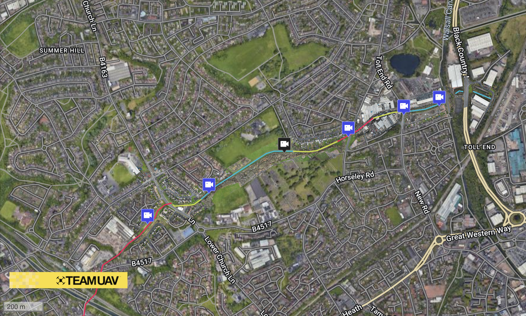
The drone’s LiDAR sensor provided critical data from within the culverts, capturing their intricate details and generating accurate 3D models. Simultaneously, drone-based photogrammetry surveys above ground mapped the surrounding area in incredible detail.
By merging these datasets, Team UAV produced a comprehensive point cloud, showing the culverts below ground as well as the above-ground features such as roads and buildings where the culverts were beneath. Thus, the culverts' positions were confirmed, and a detailed and navigable 3D visualisation of the environments was offered, facilitating a holistic understanding of the culvert systems.
The data could then be interrogated on a desktop computer, Laptop or VR headset, where the user is placed inside the structure.
Detailed Visual Inspection
The technology allowed for the capture of high-definition video revealing intricate details of the culvert interiors that are crucial for a comprehensive assessment. The visual data collected can provide clear evidence of structural dilapidations such as cracks, erosion, and other signs of wear that could threaten integrity.
Additionally, the inspections highlighted potential hazards, including water flow disruptions and the presence of obstructions like debris and sediment build-up, which pose risks to the culvert's functionality and overall safety.
By employing this advanced drone technology, Team UAV significantly reduced the risks associated with manual entry into these confined spaces, streamlining the inspection process while ensuring thoroughness and safety.
Team UAV confined space drone flying through various culverts to show a typical survey's general flight
Advantages Over Manned Entry
The traditional method of manned entry for confined space inspections is fraught with hazards, potentially exposing inspectors to dangerous conditions and requiring significant safety measures. Compared to this approach, Team UAV's drone-based method offered numerous advantages:

Enhanced Safety: The drone inspections significantly reduced the risk of potential injury by eliminating the need for personnel to enter confined spaces.
Comprehensive Data Collection: The combination of LiDAR and high-definition video provided a level of detail far beyond manual inspections.
Efficiency and Accessibility: Drones quickly cover areas that are difficult or dangerous to access, saving significant time and resources.
Predictive Maintenance: High-resolution imagery and accurate 3D models support the early identification of potential failure points. Dense point clouds show the positions of faults in an easy-to-navigate way, reducing the time needed in the data review and reporting phase of the process.
Cost-Effectiveness: Drone inspections lower the overall cost by reducing the need for manned entry and the associated safety preparations.

The Importance of Experienced Pilots
The pivotal role of highly experienced pilots in the successful execution of the project cannot be overstated. At Team UAV, we pride ourselves on having a cadre of seasoned pilots with thousands of hours of flights behind them, whose unparalleled expertise and proficiency in operating the confined space drone were instrumental in ensuring the collection of high-quality, actionable data.
Our skilled professional pilots possess an in-depth understanding of the drone's capabilities and leverage this knowledge to execute flights with precision and efficiency, even in the most challenging environments.
Their adeptness at manoeuvring the drone through intricate confined spaces is a testament to their extensive training and experience. This skill set is not only essential for capturing detailed visual data but also for maintaining the highest standards of safety during operations.
The complex nature of the confined space inspection required a nuanced approach to navigation, where every movement and adjustment needed to be calculated with the utmost precision to avoid obstacles and ensure comprehensive coverage of the inspected area. Moreover, the success of such drone-based inspection services relies on the operator's ability to adapt to varying conditions and make real-time decisions that could impact the outcome of the mission.
Our pilots' familiarity with the operational environment, coupled with their quick thinking and problem-solving abilities, played a crucial role in overcoming these challenges during the flights. Their capacity to anticipate and mitigate risks not only safeguarded the integrity of the drone and the safety of the operation but also ensured that the data collected met the highest standards of quality and reliability.
Conclusion
Team UAV's use of confined space drones represents a significant advancement in the inspection and management of confined spaces.
By harnessing drone technology, Utility providers can now achieve accurate, safe, and efficient inspections, ensuring the longevity and reliability of their essential assets.
This project not only highlights the potential for modern technology to enhance infrastructure maintenance but also sets a precedent for future applications in various sectors, promoting safety, sustainability, and operational efficiency.