
What is LiDAR, and how does it work?
The Evolution of LiDAR Technology
LiDAR technology, known for its high precision in distance measurement and 3D mapping, has undergone significant transformations since its inception. Traditionally, LiDAR systems relied on various platforms such as handheld sensors, aircraft-mounted sensors, and satellite-based systems. Each of these platforms offered distinct advantages and limitations, balancing factors like flexibility, coverage area, cost, and accuracy.
In recent years, however, the advent of LiDAR-equipped drones has revolutionised the field. The global market for LiDAR drones, valued at $114.3 million in 2021, is projected to soar to approximately $892 million by 2032. This surge in popularity is due to the versatility and efficiency that LiDAR drones bring to a multitude of sectors.
Applications of LiDAR Drone Services
LiDAR drone services have become essential across various industries, enhancing capabilities in industrial inspections, surveying, and mapping. These services are invaluable in fields like topography, cartography, and underwater bathymetry. Moreover, they are transforming industries including construction, forestry, agriculture, and inspections of power lines, oil, and gas facilities.
Understanding LiDAR Technology
LiDAR, which stands for Light Detection and Ranging, is a sophisticated technology used for collecting precise 3D data. It operates by emitting laser beams and measuring the time it takes for the light to reflect back from a target. This process allows for the creation of detailed 3D maps and models from a distance.
There are two primary types of LiDAR: topographic and bathymetric. Topographic LiDAR uses near-infrared lasers to map land-based features, while bathymetric LiDAR employs green lasers capable of penetrating water to measure underwater elevations.
Core Components of LiDAR Systems
A typical LiDAR system includes several key components:
Laser: High-powered lasers emit focused light beams that reflect off objects like trees, buildings, and the ground.
Scanner/Sensor: The scanner captures the reflected laser pulses, using various lenses and optics tailored to specific applications.
Global Positioning System (GPS): Advanced GPS and navigation systems ensure accurate positioning and orientation of the sensor.
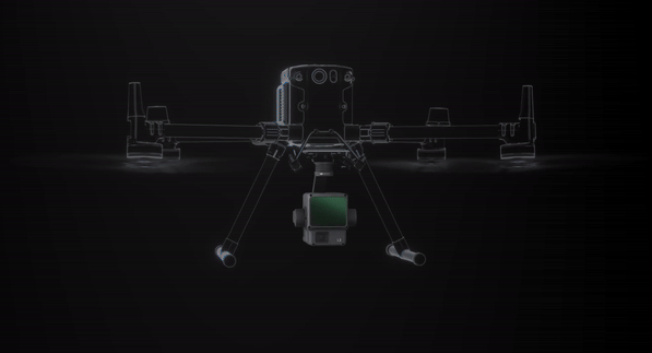
Additional components such as batteries, imaging systems, and data collectors vary based on the specific application, but the fundamental principles of LiDAR remain consistent.
How LiDAR Works and Penetrates Canopies
LiDAR, or Light Detection and Ranging, operates by emitting laser beams that travel to a target and reflect back to the sensor. This process allows for the collection of precise 3D data, essential for creating detailed maps and models. The fundamental steps involved in LiDAR operation include:
Laser Emission: The LiDAR system emits a high-powered laser beam, usually in the near-infrared spectrum for topographic applications.
Light Reflection: The laser beam travels through the air until it encounters an object, such as the ground, a tree, or a building. Upon hitting the object, the laser light reflects back to the LiDAR sensor.
Distance Measurement: The LiDAR system measures the time it takes for the laser beam to return, known as the "range." This time measurement is then used to calculate the distance between the LiDAR sensor and the object.
Data Recording: Along with the time measurement, the LiDAR system records the intensity of the reflected light and the angle of the reflection, enabling the creation of highly detailed 3D models.
Penetrating Canopies and Vegetation
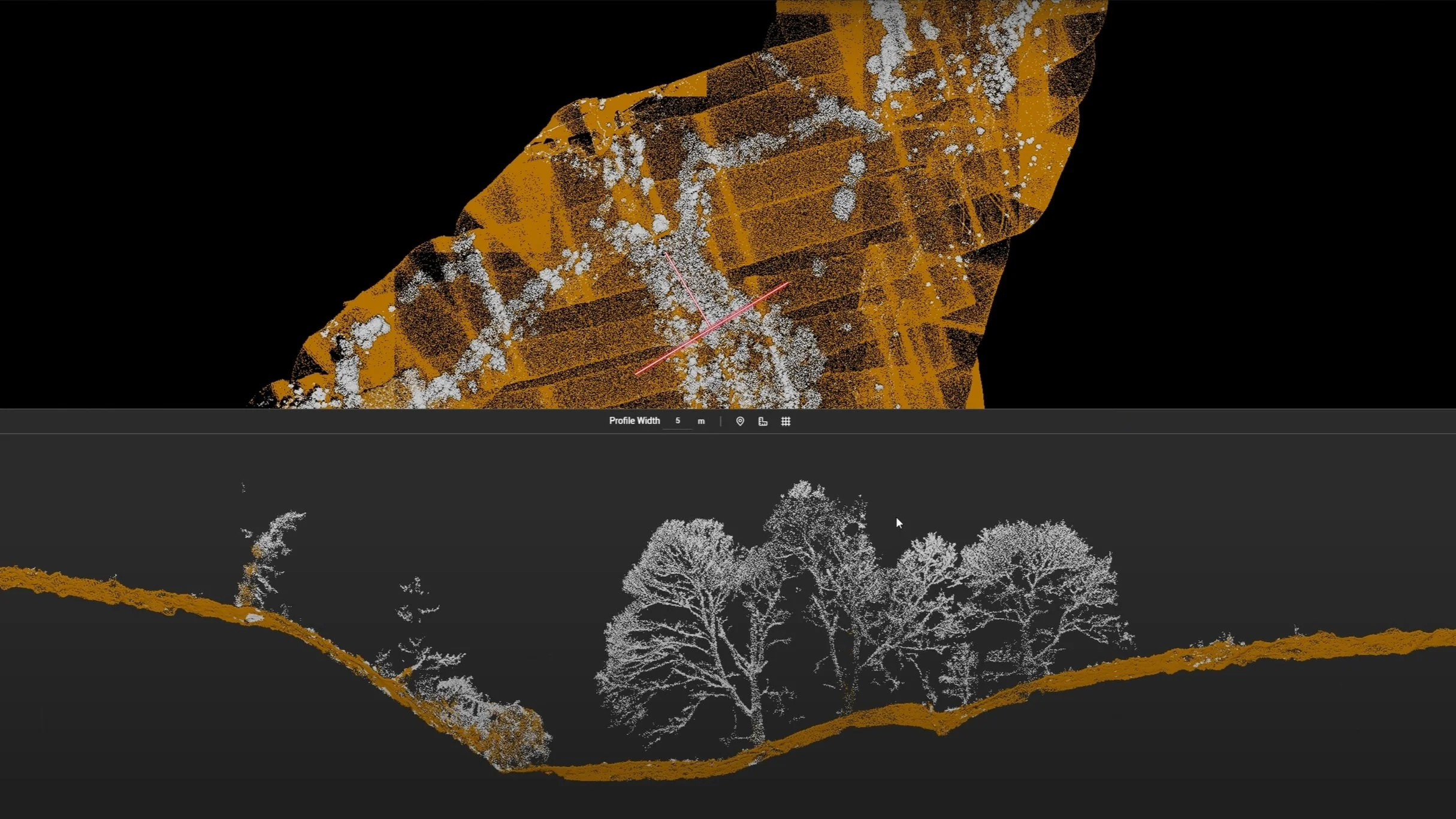
One of the remarkable capabilities of LiDAR technology is its ability to penetrate through canopies and vegetation, providing detailed information about the ground surface beneath dense foliage. This is particularly valuable in fields such as forestry, archaeology, and environmental monitoring. Here's how LiDAR achieves this:
Multiple Returns: LiDAR systems can detect multiple returns from a single laser pulse. When a laser beam is emitted from the LiDAR sensor, it may encounter several objects along its path. For instance, in a forest, the laser beam might first hit the tree canopy, then branches, and finally the ground. The LiDAR sensor records all these reflections, allowing it to distinguish between different layers of vegetation and the ground surface.
High Point Density: LiDAR emits thousands of laser pulses per second, covering large areas with high point density. This dense coverage increases the likelihood of laser beams penetrating through gaps in the canopy to reach the ground, providing accurate topographic data even in heavily vegetated areas.
Variable Pulse Intensity: LiDAR systems can adjust the intensity of their laser pulses to enhance penetration through dense vegetation. Stronger pulses are more likely to penetrate through thick canopies, while lower intensity pulses can capture finer details of the canopy structure itself.
Data Processing Algorithms: Advanced algorithms process the multiple returns and varying intensities to create a comprehensive 3D model. These algorithms filter out the noise and separate the different layers of vegetation from the ground surface, resulting in detailed and accurate terrain maps.
Applications Benefiting from Canopy Penetration
The ability of LiDAR to penetrate canopies and vegetation has numerous practical applications:
Forestry Management: LiDAR provides detailed information on tree height, density, and canopy structure, aiding in forest health assessment, timber inventory, and sustainable management practices.
Archaeological Discoveries: In dense forest regions, LiDAR can reveal hidden archaeological features such as ancient roads, structures, and settlements that are otherwise obscured by vegetation.
Environmental Monitoring: LiDAR assists in monitoring changes in vegetation cover, soil erosion, and habitat conditions, providing valuable data for conservation and environmental protection efforts.
Agricultural Planning: By penetrating crop canopies, LiDAR helps in assessing crop health, optimising irrigation, and managing planting and harvesting schedules with greater precision.
Benefits of LiDAR Drone Services
Utilising LiDAR drone services offers numerous advantages over traditional data collection methods:
Precision and Detail: LiDAR drones provide an unprecedented level of accuracy and detail in 3D mapping, making them ideal for applications requiring high precision, such as land surveying and forestry.
Efficiency and Speed: LiDAR drones can rapidly cover large areas, significantly reducing data collection time and operational costs. Traditional methods are often time-consuming and resource-intensive.
Safety and Accessibility: LiDAR drones can access remote or hazardous areas without risking human lives. They're particularly valuable in tasks such as powerline inspections, disaster response, and environmental monitoring.
Minimal Environmental Impact: Traditional ground-based surveys can disrupt ecosystems. LiDAR drones minimise such disruptions by collecting data from above, which is crucial for ecological and environmental studies.
Versatility and Customisation: LiDAR drones can be tailored to specific needs, whether it's mapping forested terrain or surveying underwater landscapes. They offer adaptability in data collection.
Cost-Effectiveness: Despite the initial investment, using LiDAR drone services leads to long-term savings due to reduced labour and surveying costs.
Applications of LiDAR Drone Services
LiDAR drone services are utilised in a variety of applications:
Infrastructure Development: Creating precise 3D models for roads, bridges, and other infrastructure, aiding in design, construction, and monitoring.

Construction Projects: Facilitating project planning, progress monitoring, clash detection, and as-built documentation, improving construction efficiency.
Mining and Quarrying: Assessing topography, monitoring stockpiles, analysing slope stability, and conducting environmental impact assessments.

Forestry Management: Measuring canopy height, mapping forest structures, assessing wildfire risks, and detecting invasive species.

Agriculture: Analysing crop health, soil mapping, irrigation planning, and precision planting and harvesting.


Archaeology and Cultural Heritage:
Uncovering hidden features, conserving heritage sites, and documenting cultural assets.

Conservation Efforts:
Mapping ecosystems, monitoring wildlife habitats, detecting illegal activities, and managing protected areas.
Geological Surveying:
Conducting surveys, mapping faults, assessing landslide risks, and analysing landforms.
Conclusion
LiDAR drone services represent a significant advancement in data collection technology, offering unparalleled precision, efficiency, and versatility. Their applications span numerous industries, from construction and agriculture to conservation and archaeology, highlighting their transformative impact. As LiDAR technology continues to evolve, its integration with drones will further enhance its capabilities, driving innovation and efficiency across various sectors. By leveraging these advanced services, organisations can achieve superior results, ensuring accuracy, safety, and sustainability in their operations.